


bancillon rapetour

Mariolebeno
User
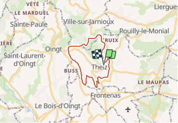

Length
11.1 km

Max alt
576 m

Uphill gradient
306 m
Km-Effort
15.2 km

Min alt
369 m

Downhill gradient
309 m
Boucle
Yes
Creation date :
2021-10-18 11:49:47.414
Updated on :
2021-10-18 11:49:50.315
3h26
Difficulty : Difficult

FREE GPS app for hiking
 SityTrail
IGN / Geographical institutes
SityTrail Plus
The world is yours!
About
Trail Walking of 11.1 km to be discovered at Auvergne-Rhône-Alpes, Rhône, Theizé. This trail is proposed by Mariolebeno.
Positioning
Country:
France
Region :
Auvergne-Rhône-Alpes
Department/Province :
Rhône
Municipality :
Theizé
Location:
Unknown
Start:(Dec)
Start:(UTM)
625425 ; 5088771 (31T) N.
Comments