


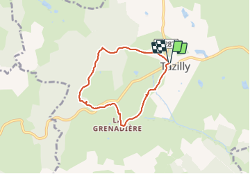
circuit de la croix Charles raourci dép Tazilly

martinjacque
User

Length
5.7 km

Max alt
425 m

Uphill gradient
142 m
Km-Effort
7.6 km

Min alt
301 m

Downhill gradient
141 m
Boucle
Yes
Creation date :
2021-10-18 12:13:09.628
Updated on :
2021-10-18 14:42:31.166
2h27
Difficulty : Easy

FREE GPS app for hiking
 SityTrail
IGN / Geographical institutes
SityTrail Plus
The world is yours!
About
Trail Walking of 5.7 km to be discovered at Bourgogne-Franche-Comté, Nièvre, Tazilly. This trail is proposed by martinjacque.
Description
***ttb avec une belle côte de 500m
Positioning
Country:
France
Region :
Bourgogne-Franche-Comté
Department/Province :
Nièvre
Municipality :
Tazilly
Location:
Unknown
Start:(Dec)
Start:(UTM)
569721 ; 5179546 (31T) N.
Comments
très beau parcours, merci à Martinjacque