


Villard Reymond

lionelnottat
User
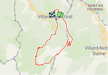

Length
10 km

Max alt
2122 m

Uphill gradient
564 m
Km-Effort
17.5 km

Min alt
1608 m

Downhill gradient
558 m
Boucle
Yes
Creation date :
2021-10-19 07:30:23.704
Updated on :
2021-10-19 13:32:02.091
3h34
Difficulty : Difficult

FREE GPS app for hiking
 SityTrail
IGN / Geographical institutes
SityTrail Plus
The world is yours!
About
Trail Walking of 10 km to be discovered at Auvergne-Rhône-Alpes, Isère, Villard-Reymond. This trail is proposed by lionelnottat.
Positioning
Country:
France
Region :
Auvergne-Rhône-Alpes
Department/Province :
Isère
Municipality :
Villard-Reymond
Location:
Unknown
Start:(Dec)
Start:(UTM)
265187 ; 4990746 (32T) N.
Comments