


Cerdon: fort; grotte; chapelle St Alban

HB01
User
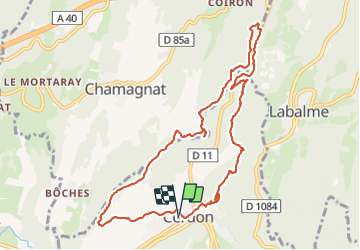

Length
10.7 km

Max alt
623 m

Uphill gradient
536 m
Km-Effort
17.8 km

Min alt
311 m

Downhill gradient
536 m
Boucle
Yes
Creation date :
2021-10-19 08:47:56.978
Updated on :
2021-10-19 15:11:51.873
3h25
Difficulty : Medium

FREE GPS app for hiking
 SityTrail
IGN / Geographical institutes
SityTrail Plus
The world is yours!
About
Trail Walking of 10.7 km to be discovered at Auvergne-Rhône-Alpes, Ain, Cerdon. This trail is proposed by HB01.
Description
Départ de Cerdon; montée à la Vierge, au fort; grotte de la Cambourne; chapelle de St Alban et descente par l'arête.
Positioning
Country:
France
Region :
Auvergne-Rhône-Alpes
Department/Province :
Ain
Municipality :
Cerdon
Location:
Unknown
Start:(Dec)
Start:(UTM)
690440 ; 5105925 (31T) N.
Comments