


sortie du 19-10-21

Didier-114
User
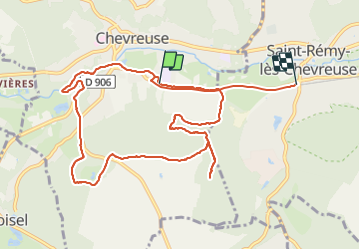

Length
11.3 km

Max alt
176 m

Uphill gradient
160 m
Km-Effort
13.5 km

Min alt
78 m

Downhill gradient
166 m
Boucle
No
Creation date :
2021-10-19 11:45:11.89
Updated on :
2021-10-19 14:59:04.036
3h12
Difficulty : Medium

FREE GPS app for hiking
 SityTrail
IGN / Geographical institutes
SityTrail Plus
The world is yours!
About
Trail Walking of 11.3 km to be discovered at Ile-de-France, Yvelines, Chevreuse. This trail is proposed by Didier-114.
Positioning
Country:
France
Region :
Ile-de-France
Department/Province :
Yvelines
Municipality :
Chevreuse
Location:
Unknown
Start:(Dec)
Start:(UTM)
429771 ; 5394853 (31U) N.
Comments