


Crêt de l' Oeillon - Crêt de Botte

VANDERPUTTENMi
User GUIDE
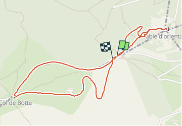

Length
3 km

Max alt
1391 m

Uphill gradient
114 m
Km-Effort
4.5 km

Min alt
1319 m

Downhill gradient
113 m
Boucle
Yes
Creation date :
2021-10-19 13:06:51.432
Updated on :
2021-10-19 21:32:08.817
53m
Difficulty : Easy

FREE GPS app for hiking
 SityTrail
IGN / Geographical institutes
SityTrail Plus
The world is yours!
About
Trail Walking of 3 km to be discovered at Auvergne-Rhône-Alpes, Loire, Doizieux. This trail is proposed by VANDERPUTTENMi.
Positioning
Country:
France
Region :
Auvergne-Rhône-Alpes
Department/Province :
Loire
Municipality :
Doizieux
Location:
Unknown
Start:(Dec)
Start:(UTM)
625860 ; 5027651 (31T) N.
Comments