


D’oranges

Pascal Bernaud
User

Length
4.7 km

Max alt
1006 m

Uphill gradient
150 m
Km-Effort
6.8 km

Min alt
875 m

Downhill gradient
177 m
Boucle
No
Creation date :
2021-10-20 13:55:14.0
Updated on :
2021-10-20 15:13:08.7
1h17
Difficulty : Medium

FREE GPS app for hiking
 SityTrail
IGN / Geographical institutes
SityTrail Plus
The world is yours!
About
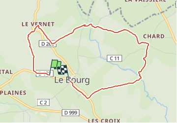
Trail Walking of 4.7 km to be discovered at Auvergne-Rhône-Alpes, Puy-de-Dôme, Doranges. This trail is proposed by Pascal Bernaud.
Positioning
Country:
France
Region :
Auvergne-Rhône-Alpes
Department/Province :
Puy-de-Dôme
Municipality :
Doranges
Location:
Unknown
Start:(Dec)
Start:(UTM)
547881 ; 5028350 (31T) N.
Comments