


rocher de Dentillon par Pélussin

psesjs
User
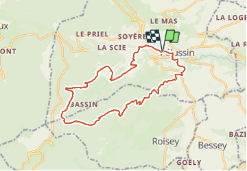

Length
17.7 km

Max alt
1026 m

Uphill gradient
690 m
Km-Effort
27 km

Min alt
409 m

Downhill gradient
691 m
Boucle
Yes
Creation date :
2021-10-20 07:23:24.11
Updated on :
2021-10-20 17:06:05.374
5h06
Difficulty : Easy

FREE GPS app for hiking
 SityTrail
IGN / Geographical institutes
SityTrail Plus
The world is yours!
About
Trail Walking of 17.7 km to be discovered at Auvergne-Rhône-Alpes, Loire, Pélussin. This trail is proposed by psesjs.
Positioning
Country:
France
Region :
Auvergne-Rhône-Alpes
Department/Province :
Loire
Municipality :
Pélussin
Location:
Unknown
Start:(Dec)
Start:(UTM)
630726 ; 5030762 (31T) N.
Comments