


Saint Christine

lygi
User
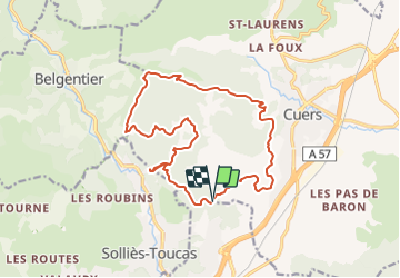

Length
17.8 km

Max alt
433 m

Uphill gradient
726 m
Km-Effort
27 km

Min alt
140 m

Downhill gradient
715 m
Boucle
Yes
Creation date :
2021-10-21 09:18:53.085
Updated on :
2021-10-21 09:21:38.195
6h13
Difficulty : Very difficult

FREE GPS app for hiking
 SityTrail
IGN / Geographical institutes
SityTrail Plus
The world is yours!
About
Trail Walking of 17.8 km to be discovered at Provence-Alpes-Côte d'Azur, Var, Cuers. This trail is proposed by lygi.
Description
Moyenne randonnee
Positioning
Country:
France
Region :
Provence-Alpes-Côte d'Azur
Department/Province :
Var
Municipality :
Cuers
Location:
Unknown
Start:(Dec)
Start:(UTM)
259992 ; 4789212 (32T) N.
Comments
très mal tracée. trop de tirés droits.