


Gorges du Blavet - Oppidum - Meules de pierres

affinetataille
User GUIDE
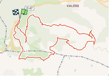

Length
15.6 km

Max alt
419 m

Uphill gradient
568 m
Km-Effort
23 km

Min alt
91 m

Downhill gradient
568 m
Boucle
Yes
Creation date :
2021-10-21 07:41:55.714
Updated on :
2022-06-19 00:03:26.678
7h00
Difficulty : Medium

FREE GPS app for hiking
 SityTrail
IGN / Geographical institutes
SityTrail Plus
The world is yours!
About
Trail Walking of 15.6 km to be discovered at Provence-Alpes-Côte d'Azur, Var, Bagnols-en-Forêt. This trail is proposed by affinetataille.
Positioning
Country:
France
Region :
Provence-Alpes-Côte d'Azur
Department/Province :
Var
Municipality :
Bagnols-en-Forêt
Location:
Unknown
Start:(Dec)
Start:(UTM)
310492 ; 4822194 (32T) N.
Comments