


Puy St Vincent - le Puy - 2,6 km

mhetpierre
User
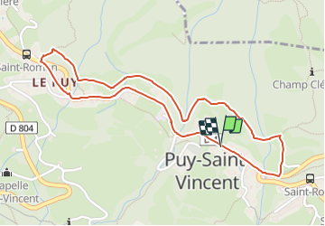

Length
2.6 km

Max alt
1393 m

Uphill gradient
54 m
Km-Effort
3.3 km

Min alt
1349 m

Downhill gradient
55 m
Boucle
Yes
Creation date :
2021-10-22 06:57:18.0
Updated on :
2021-11-07 10:27:16.756
44m
Difficulty : Easy

FREE GPS app for hiking
 SityTrail
IGN / Geographical institutes
SityTrail Plus
The world is yours!
About
Trail Walking of 2.6 km to be discovered at Provence-Alpes-Côte d'Azur, Hautes-Alpes, Puy-Saint-Vincent. This trail is proposed by mhetpierre.
Positioning
Country:
France
Region :
Provence-Alpes-Côte d'Azur
Department/Province :
Hautes-Alpes
Municipality :
Puy-Saint-Vincent
Location:
Unknown
Start:(Dec)
Start:(UTM)
301842 ; 4966991 (32T) N.
Comments