


Trace réelle ttvexinbray du 4 juillet 2020

olivieraron
User
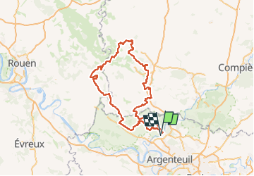

Length
243 km

Max alt
230 m

Uphill gradient
2876 m
Km-Effort
282 km

Min alt
29 m

Downhill gradient
2906 m
Boucle
No
Creation date :
2021-10-23 06:57:05.413
Updated on :
2021-10-23 06:57:05.413

FREE GPS app for hiking
 SityTrail
IGN / Geographical institutes
SityTrail Plus
The world is yours!
About
Trail of 243 km to be discovered at Ile-de-France, Val-d'Oise, Auvers-sur-Oise. This trail is proposed by olivieraron.
Positioning
Country:
France
Region :
Ile-de-France
Department/Province :
Val-d'Oise
Municipality :
Auvers-sur-Oise
Location:
Unknown
Start:(Dec)
Start:(UTM)
440002 ; 5436142 (31U) N.
Comments