


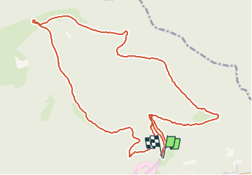
Schirmeck - sentier du Colbéry

Bart2015
User


1h45
Difficulty : Easy

FREE GPS app for hiking
 SityTrail
IGN / Geographical institutes
SityTrail Plus
The world is yours!
About
Trail Walking of 6.5 km to be discovered at Grand Est, Bas-Rhin, Schirmeck. This trail is proposed by Bart2015.
Description
Belle randonnée pour découvrir un petit coin de paradis avec de magnifiques vues. Belle aire de pique-nique à l'abri du Colbéry. A faire avec des enfants. Dans ce cas, le retour peut se faire par le même chemin.
Bonne rando ...
Photos


Positioning
Comments