


abbaye d'aulnes

brunobuj
User
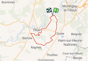

Length
22 km

Max alt
208 m

Uphill gradient
309 m
Km-Effort
26 km

Min alt
111 m

Downhill gradient
304 m
Boucle
Yes
Creation date :
2021-10-23 07:40:20.321
Updated on :
2021-10-23 14:45:39.297
7h04
Difficulty : Very difficult

FREE GPS app for hiking
 SityTrail
IGN / Geographical institutes
SityTrail Plus
The world is yours!
About
Trail Walking of 22 km to be discovered at Wallonia, Hainaut, Thuin. This trail is proposed by brunobuj.
Positioning
Country:
Belgium
Region :
Wallonia
Department/Province :
Hainaut
Municipality :
Thuin
Location:
Unknown
Start:(Dec)
Start:(UTM)
594657 ; 5580068 (31U) N.
Comments