


Odenas St ETienne la varenne 69

aupi
User
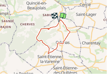

Length
10.8 km

Max alt
628 m

Uphill gradient
374 m
Km-Effort
15.8 km

Min alt
265 m

Downhill gradient
374 m
Boucle
Yes
Creation date :
2021-10-14 11:55:24.663
Updated on :
2021-10-23 14:48:17.555
3h49
Difficulty : Medium

FREE GPS app for hiking
 SityTrail
IGN / Geographical institutes
SityTrail Plus
The world is yours!
About
Trail Walking of 10.8 km to be discovered at Auvergne-Rhône-Alpes, Rhône, Odenas. This trail is proposed by aupi.
Photos

Positioning
Country:
France
Region :
Auvergne-Rhône-Alpes
Department/Province :
Rhône
Municipality :
Odenas
Location:
Unknown
Start:(Dec)
Start:(UTM)
626894 ; 5106995 (31T) N.
Comments