


Château-Renault - GR655ouest Villechauve - 21.9km 235m 4h55 (30mn) - 2021 10 23

Orcal37
User GUIDE
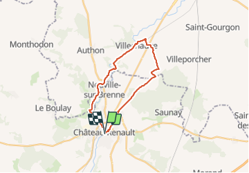

Length
22 km

Max alt
138 m

Uphill gradient
235 m
Km-Effort
25 km

Min alt
87 m

Downhill gradient
236 m
Boucle
Yes
Creation date :
2021-10-23 09:15:01.507
Updated on :
2021-10-24 14:56:53.056
4h55
Difficulty : Easy

FREE GPS app for hiking
 SityTrail
IGN / Geographical institutes
SityTrail Plus
The world is yours!
About
Trail Walking of 22 km to be discovered at Centre-Loire Valley, Indre-et-Loire, Château-Renault. This trail is proposed by Orcal37.
Description
Château-Renault - GR655ouest Villechauve - 21.9km 235m 4h55 (30mn) - 2021 10 23
Photos
 - 2021 10 23 - Photo 1")
 - 2021 10 23 - Photo 2")
 - 2021 10 23 - Photo 3")
 - 2021 10 23 - Photo 4")
 - 2021 10 23 - Photo 5")
 - 2021 10 23 - Photo 6")
 - 2021 10 23 - Photo 7")
Positioning
Country:
France
Region :
Centre-Loire Valley
Department/Province :
Indre-et-Loire
Municipality :
Château-Renault
Location:
Unknown
Start:(Dec)
Start:(UTM)
342822 ; 5272766 (31T) N.
Comments