


Vendôme 24.10.2021

jackalv
User
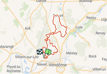

Length
36 km

Max alt
153 m

Uphill gradient
454 m
Km-Effort
42 km

Min alt
79 m

Downhill gradient
454 m
Boucle
Yes
Creation date :
2021-10-24 05:07:36.574
Updated on :
2021-10-24 11:33:21.828
6h24
Difficulty : Easy

FREE GPS app for hiking
 SityTrail
IGN / Geographical institutes
SityTrail Plus
The world is yours!
About
Trail Walking of 36 km to be discovered at Centre-Loire Valley, Loir-et-Cher, Vendôme. This trail is proposed by jackalv.
Positioning
Country:
France
Region :
Centre-Loire Valley
Department/Province :
Loir-et-Cher
Municipality :
Vendôme
Location:
Unknown
Start:(Dec)
Start:(UTM)
352848 ; 5296297 (31T) N.
Comments