


le rangeais

micheleuvrard
User

Length
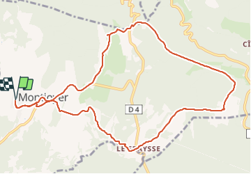
12.5 km

Max alt
452 m

Uphill gradient
227 m
Km-Effort
15.5 km

Min alt
312 m

Downhill gradient
229 m
Boucle
Yes
Creation date :
2021-10-24 11:57:30.405
Updated on :
2021-10-24 15:36:19.117
3h37
Difficulty : Difficult

FREE GPS app for hiking
 SityTrail
IGN / Geographical institutes
SityTrail Plus
The world is yours!
About
Trail Walking of 12.5 km to be discovered at Auvergne-Rhône-Alpes, Drôme, Montjoyer. This trail is proposed by micheleuvrard.
Description
4
Photos


Positioning
Country:
France
Region :
Auvergne-Rhône-Alpes
Department/Province :
Drôme
Municipality :
Montjoyer
Location:
Unknown
Start:(Dec)
Start:(UTM)
646876 ; 4926506 (31T) N.
Comments