


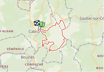
2020-09-17-46-FORET DE MONTCLAR Cabreret

houbart
User

Length
13.2 km

Max alt
326 m

Uphill gradient
464 m
Km-Effort
19.4 km

Min alt
134 m

Downhill gradient
473 m
Boucle
No
Creation date :
2021-10-24 17:54:44.912
Updated on :
2021-10-24 17:57:13.493
4h24
Difficulty : Very difficult

FREE GPS app for hiking
 SityTrail
IGN / Geographical institutes
SityTrail Plus
The world is yours!
About
Trail Walking of 13.2 km to be discovered at Occitania, Lot, Cabrerets. This trail is proposed by houbart.
Description
Belle randonnée de 13km dans la foret de Montclar 400m de dénivelé positif vous attendent sur de larges allées. de beaux paysages sur cabrerets a decouvrir tout au long du circuit
Positioning
Country:
France
Region :
Occitania
Department/Province :
Lot
Municipality :
Cabrerets
Location:
Unknown
Start:(Dec)
Start:(UTM)
393099 ; 4928984 (31T) N.
Comments