


Cuges / Jas de Miceau

francisdean
User
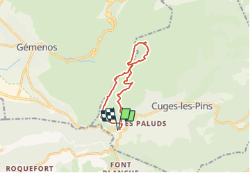

Length
12 km

Max alt
643 m

Uphill gradient
480 m
Km-Effort
18.4 km

Min alt
220 m

Downhill gradient
479 m
Boucle
Yes
Creation date :
2021-10-25 07:15:36.659
Updated on :
2021-10-25 07:16:31.121
4h10
Difficulty : Medium

FREE GPS app for hiking
 SityTrail
IGN / Geographical institutes
SityTrail Plus
The world is yours!
About
Trail Walking of 12 km to be discovered at Provence-Alpes-Côte d'Azur, Bouches-du-Rhône, Cuges-les-Pins. This trail is proposed by francisdean.
Positioning
Country:
France
Region :
Provence-Alpes-Côte d'Azur
Department/Province :
Bouches-du-Rhône
Municipality :
Cuges-les-Pins
Location:
Unknown
Start:(Dec)
Start:(UTM)
716670 ; 4793804 (31T) N.
Comments