


Le Suillet

Clo0413
User
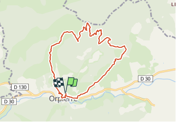

Length
9.7 km

Max alt
1314 m

Uphill gradient
634 m
Km-Effort
18.2 km

Min alt
687 m

Downhill gradient
636 m
Boucle
Yes
Creation date :
2021-10-25 07:34:16.051
Updated on :
2021-10-26 17:26:27.377
3h04
Difficulty : Medium

FREE GPS app for hiking
 SityTrail
IGN / Geographical institutes
SityTrail Plus
The world is yours!
About
Trail Walking of 9.7 km to be discovered at Provence-Alpes-Côte d'Azur, Hautes-Alpes, Orpierre. This trail is proposed by Clo0413.
Positioning
Country:
France
Region :
Provence-Alpes-Côte d'Azur
Department/Province :
Hautes-Alpes
Municipality :
Orpierre
Location:
Unknown
Start:(Dec)
Start:(UTM)
714745 ; 4910346 (31T) N.
Comments