


cretes vercors est

aldaus
User
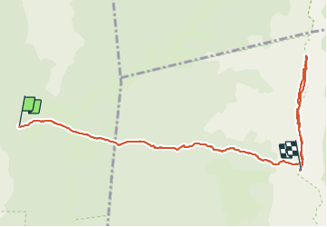

Length
8.9 km

Max alt
2078 m

Uphill gradient
783 m
Km-Effort
17.6 km

Min alt
1373 m

Downhill gradient
261 m
Boucle
No
Creation date :
2021-10-26 10:29:58.89
Updated on :
2021-10-26 16:43:53.297
5h11
Difficulty : Easy

FREE GPS app for hiking
 SityTrail
IGN / Geographical institutes
SityTrail Plus
The world is yours!
About
Trail Walking of 8.9 km to be discovered at Auvergne-Rhône-Alpes, Drôme, Saint-Agnan-en-Vercors. This trail is proposed by aldaus.
Positioning
Country:
France
Region :
Auvergne-Rhône-Alpes
Department/Province :
Drôme
Municipality :
Saint-Agnan-en-Vercors
Location:
Unknown
Start:(Dec)
Start:(UTM)
694515 ; 4976643 (31T) N.
Comments