


2021-10-27_20h04m59_2021-10-27_539533857_Col de la Gardiole – Port Pin Circuit à partir de Cassis (2)

HG74250
User
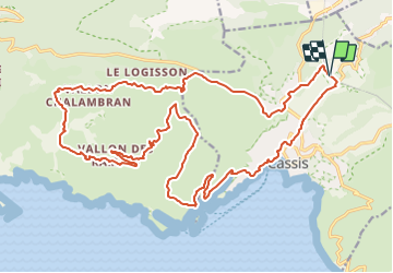

Length
29 km

Max alt
513 m

Uphill gradient
883 m
Km-Effort
41 km

Min alt
8 m

Downhill gradient
881 m
Boucle
Yes
Creation date :
2021-10-27 18:05:00.521
Updated on :
2021-10-27 18:41:24.477
2h50
Difficulty : Difficult

FREE GPS app for hiking
 SityTrail
IGN / Geographical institutes
SityTrail Plus
The world is yours!
About
Trail Mountain bike of 29 km to be discovered at Provence-Alpes-Côte d'Azur, Bouches-du-Rhône, Cassis. This trail is proposed by HG74250.
Positioning
Country:
France
Region :
Provence-Alpes-Côte d'Azur
Department/Province :
Bouches-du-Rhône
Municipality :
Cassis
Location:
Unknown
Start:(Dec)
Start:(UTM)
707300 ; 4789958 (31T) N.
Comments