


2021-10-27_20h09m15_2021-10-27_539539251_Route de la Gineste – Port Pin Circuit à partir de Carpiagne

HG74250
User
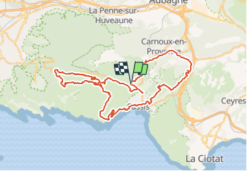

Length
44 km

Max alt
395 m

Uphill gradient
1052 m
Km-Effort
58 km

Min alt
5 m

Downhill gradient
1054 m
Boucle
Yes
Creation date :
2021-10-27 18:09:16.581
Updated on :
2021-10-27 18:40:42.095
3h59
Difficulty : Very difficult

FREE GPS app for hiking
 SityTrail
IGN / Geographical institutes
SityTrail Plus
The world is yours!
About
Trail Mountain bike of 44 km to be discovered at Provence-Alpes-Côte d'Azur, Bouches-du-Rhône, Cassis. This trail is proposed by HG74250.
Positioning
Country:
France
Region :
Provence-Alpes-Côte d'Azur
Department/Province :
Bouches-du-Rhône
Municipality :
Cassis
Location:
Unknown
Start:(Dec)
Start:(UTM)
705686 ; 4789521 (31T) N.
Comments