


2021-10-27_20h10m27_2021-10-27_539540933_Vue baie de Cassis Circuit à partir de Cassis

HG74250
User
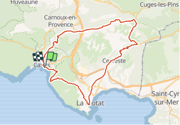

Length
40 km

Max alt
405 m

Uphill gradient
939 m
Km-Effort
53 km

Min alt
6 m

Downhill gradient
944 m
Boucle
Yes
Creation date :
2021-10-27 18:10:28.589
Updated on :
2021-10-27 18:46:39.229
3h40
Difficulty : Very difficult

FREE GPS app for hiking
 SityTrail
IGN / Geographical institutes
SityTrail Plus
The world is yours!
About
Trail Mountain bike of 40 km to be discovered at Provence-Alpes-Côte d'Azur, Bouches-du-Rhône, Cassis. This trail is proposed by HG74250.
Positioning
Country:
France
Region :
Provence-Alpes-Côte d'Azur
Department/Province :
Bouches-du-Rhône
Municipality :
Cassis
Location:
Unknown
Start:(Dec)
Start:(UTM)
706691 ; 4787415 (31T) N.
Comments