


2021-10-27_20h15m12_dessous-route-des-cretes-cassis

HG74250
User
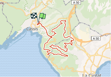

Length
24 km

Max alt
329 m

Uphill gradient
872 m
Km-Effort
35 km

Min alt
36 m

Downhill gradient
868 m
Boucle
Yes
Creation date :
2021-10-27 18:15:12.46
Updated on :
2021-10-27 18:44:00.322
2h27
Difficulty : Difficult

FREE GPS app for hiking
 SityTrail
IGN / Geographical institutes
SityTrail Plus
The world is yours!
About
Trail Mountain bike of 24 km to be discovered at Provence-Alpes-Côte d'Azur, Bouches-du-Rhône, Cassis. This trail is proposed by HG74250.
Description
Route des cretes cassis
Positioning
Country:
France
Region :
Provence-Alpes-Côte d'Azur
Department/Province :
Bouches-du-Rhône
Municipality :
Cassis
Location:
Unknown
Start:(Dec)
Start:(UTM)
706826 ; 4788247 (31T) N.
Comments