


St Romain puymeras faucon 84

aupi
User
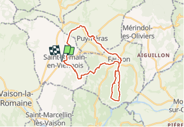

Length
16.5 km

Max alt
451 m

Uphill gradient
440 m
Km-Effort
22 km

Min alt
251 m

Downhill gradient
440 m
Boucle
Yes
Creation date :
2021-10-28 07:26:49.457
Updated on :
2021-10-28 15:16:06.022
6h03
Difficulty : Medium

FREE GPS app for hiking
 SityTrail
IGN / Geographical institutes
SityTrail Plus
The world is yours!
About
Trail Walking of 16.5 km to be discovered at Provence-Alpes-Côte d'Azur, Vaucluse, Saint-Romain-en-Viennois. This trail is proposed by aupi.
Positioning
Country:
France
Region :
Provence-Alpes-Côte d'Azur
Department/Province :
Vaucluse
Municipality :
Saint-Romain-en-Viennois
Location:
Unknown
Start:(Dec)
Start:(UTM)
668187 ; 4902728 (31T) N.
Comments