


SityTrail - 26/06/2019 - SION LES MINES OUEST ET EST.Virtuel

chasle
User
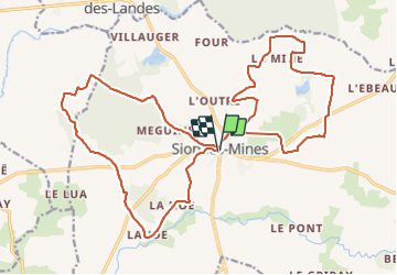

Length
24 km

Max alt
83 m

Uphill gradient
195 m
Km-Effort
27 km

Min alt
20 m

Downhill gradient
198 m
Boucle
Yes
Creation date :
2021-10-28 16:17:57.419
Updated on :
2021-10-28 16:35:10.667
6h09
Difficulty : Easy

FREE GPS app for hiking
 SityTrail
IGN / Geographical institutes
SityTrail Plus
The world is yours!
About
Trail Walking of 24 km to be discovered at Pays de la Loire, Loire-Atlantique, Sion-les-Mines. This trail is proposed by chasle.
Positioning
Country:
France
Region :
Pays de la Loire
Department/Province :
Loire-Atlantique
Municipality :
Sion-les-Mines
Location:
Unknown
Start:(Dec)
Start:(UTM)
605552 ; 5287773 (30T) N.
Comments