


yzeron - Bellevue - col des brosses

XavierFaidix
User
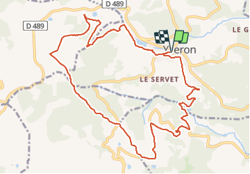

Length
12.8 km

Max alt
899 m

Uphill gradient
450 m
Km-Effort
18.8 km

Min alt
510 m

Downhill gradient
450 m
Boucle
Yes
Creation date :
2021-10-29 10:41:48.598
Updated on :
2021-10-29 19:25:17.11
3h24
Difficulty : Medium

FREE GPS app for hiking
 SityTrail
IGN / Geographical institutes
SityTrail Plus
The world is yours!
About
Trail Walking of 12.8 km to be discovered at Auvergne-Rhône-Alpes, Rhône, Yzeron. This trail is proposed by XavierFaidix.
Positioning
Country:
France
Region :
Auvergne-Rhône-Alpes
Department/Province :
Rhône
Municipality :
Yzeron
Location:
Unknown
Start:(Dec)
Start:(UTM)
623656 ; 5062745 (31T) N.
Comments