


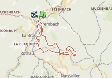
Circuit Schirmeck - Le Struthof

vaillantjm
User

Length
16 km

Max alt
796 m

Uphill gradient
681 m
Km-Effort
25 km

Min alt
312 m

Downhill gradient
681 m
Boucle
Yes
Creation date :
2021-10-30 10:25:17.808
Updated on :
2022-02-11 16:35:56.339
5h45
Difficulty : Difficult

FREE GPS app for hiking
 SityTrail
IGN / Geographical institutes
SityTrail Plus
The world is yours!
About
Trail Walking of 16 km to be discovered at Grand Est, Bas-Rhin, Schirmeck. This trail is proposed by vaillantjm.
Positioning
Country:
France
Region :
Grand Est
Department/Province :
Bas-Rhin
Municipality :
Schirmeck
Location:
Unknown
Start:(Dec)
Start:(UTM)
368430 ; 5371008 (32U) N.
Comments