


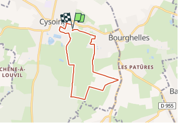
Cysoing 6.6

temjacques
User

Length
6.6 km

Max alt
41 m

Uphill gradient
39 m
Km-Effort
7.2 km

Min alt
30 m

Downhill gradient
40 m
Boucle
Yes
Creation date :
2021-10-31 09:36:45.251
Updated on :
2021-10-31 09:37:28.773
1h37
Difficulty : Medium

FREE GPS app for hiking
 SityTrail
IGN / Geographical institutes
SityTrail Plus
The world is yours!
About
Trail Walking of 6.6 km to be discovered at Hauts-de-France, Nord, Cysoing. This trail is proposed by temjacques.
Positioning
Country:
France
Region :
Hauts-de-France
Department/Province :
Nord
Municipality :
Cysoing
Location:
Unknown
Start:(Dec)
Start:(UTM)
515750 ; 5601598 (31U) N.
Comments