


huchere.rd cailloux. bennevise.bambois.

GuySimonin
User
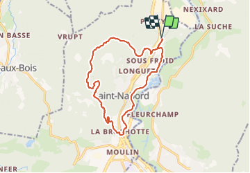

Length
14.4 km

Max alt
634 m

Uphill gradient
370 m
Km-Effort
19.4 km

Min alt
379 m

Downhill gradient
370 m
Boucle
Yes
Creation date :
2021-10-31 08:58:20.248
Updated on :
2021-10-31 11:03:34.126
1h57
Difficulty : Easy

FREE GPS app for hiking
 SityTrail
IGN / Geographical institutes
SityTrail Plus
The world is yours!
About
Trail Running of 14.4 km to be discovered at Grand Est, Vosges, Saint-Nabord. This trail is proposed by GuySimonin.
Positioning
Country:
France
Region :
Grand Est
Department/Province :
Vosges
Municipality :
Saint-Nabord
Location:
Unknown
Start:(Dec)
Start:(UTM)
321066 ; 5326489 (32U) N.
Comments