


Uriage - Villeneuve

lionelnottat
User
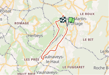

Length
10.5 km

Max alt
621 m

Uphill gradient
328 m
Km-Effort
14.9 km

Min alt
379 m

Downhill gradient
337 m
Boucle
Yes
Creation date :
2021-11-01 07:30:25.715
Updated on :
2021-11-01 07:31:37.262
3h22
Difficulty : Difficult

FREE GPS app for hiking
 SityTrail
IGN / Geographical institutes
SityTrail Plus
The world is yours!
About
Trail Walking of 10.5 km to be discovered at Auvergne-Rhône-Alpes, Isère, Saint-Martin-d'Uriage. This trail is proposed by lionelnottat.
Positioning
Country:
France
Region :
Auvergne-Rhône-Alpes
Department/Province :
Isère
Municipality :
Saint-Martin-d'Uriage
Location:
Unknown
Start:(Dec)
Start:(UTM)
722462 ; 5003061 (31T) N.
Comments