


les Hauts Cognets

RobinMicheline
User GUIDE
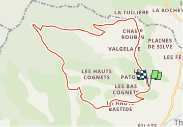

Length
11.3 km

Max alt
1352 m

Uphill gradient
592 m
Km-Effort
19.2 km

Min alt
776 m

Downhill gradient
592 m
Boucle
Yes
Creation date :
2021-11-01 13:42:30.052
Updated on :
2021-11-02 18:14:45.878
4h21
Difficulty : Very difficult

FREE GPS app for hiking
 SityTrail
IGN / Geographical institutes
SityTrail Plus
The world is yours!
About
Trail Walking of 11.3 km to be discovered at Provence-Alpes-Côte d'Azur, Alpes-de-Haute-Provence, Thoard. This trail is proposed by RobinMicheline.
Positioning
Country:
France
Region :
Provence-Alpes-Côte d'Azur
Department/Province :
Alpes-de-Haute-Provence
Municipality :
Thoard
Location:
Unknown
Start:(Dec)
Start:(UTM)
270926 ; 4893465 (32T) N.
Comments