


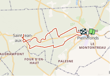
De Pierrefonds à St Jean-aux-bois

Greg813
User


4h05
Difficulty : Medium

FREE GPS app for hiking
 SityTrail
IGN / Geographical institutes
SityTrail Plus
The world is yours!
About
Trail Walking of 16.8 km to be discovered at Hauts-de-France, Oise, Pierrefonds. This trail is proposed by Greg813.
Description
Randonnées avec Mettons le Monde en Marche au départ du château de Pierrefonds (prévoir 1/2 journée supplémentaire pour la visite du château).
A travers les forêts jusqu'à St Jean-aux-bois, petite village pittoresque qui vaut quelques détours !
Pour d'autres photos, voir le site de l'association :
https://mmm-rando.org/week-end-halloween-compiegne-2021/
Photos

Positioning
Comments