


depart cimetiere de marnay

gerardmicheline
User
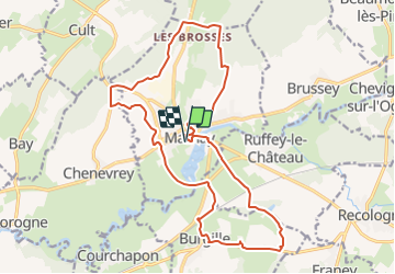

Length
19.9 km

Max alt
298 m

Uphill gradient
310 m
Km-Effort
24 km

Min alt
197 m

Downhill gradient
309 m
Boucle
Yes
Creation date :
2021-11-01 14:34:29.27
Updated on :
2021-11-01 14:35:04.191
5h27
Difficulty : Very difficult

FREE GPS app for hiking
 SityTrail
IGN / Geographical institutes
SityTrail Plus
The world is yours!
About
Trail Walking of 19.9 km to be discovered at Bourgogne-Franche-Comté, Haute-Saône, Marnay. This trail is proposed by gerardmicheline.
Positioning
Country:
France
Region :
Bourgogne-Franche-Comté
Department/Province :
Haute-Saône
Municipality :
Marnay
Location:
Unknown
Start:(Dec)
Start:(UTM)
709448 ; 5240974 (31T) N.
Comments