


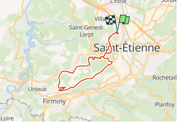
Bel Air Tunnels Croix De Marlet

psesjs
User

Length
29 km

Max alt
701 m

Uphill gradient
674 m
Km-Effort
38 km

Min alt
462 m

Downhill gradient
673 m
Boucle
Yes
Creation date :
2021-11-01 13:59:29.242
Updated on :
2021-11-01 17:43:45.445
1h56
Difficulty : Medium
2h00
Difficulty : Easy

FREE GPS app for hiking
 SityTrail
IGN / Geographical institutes
SityTrail Plus
The world is yours!
About
Trail Mountain bike of 29 km to be discovered at Auvergne-Rhône-Alpes, Loire, Saint-Étienne. This trail is proposed by psesjs.
Description
Prévoir une lampe frontale pour passage des tunnels.
Cette randonnée permet de découvrir le passé minier de Firminy. Ce tracé passe sur l'ancienne voie de chemin de fer...
Positioning
Country:
France
Region :
Auvergne-Rhône-Alpes
Department/Province :
Loire
Municipality :
Saint-Étienne
Location:
Unknown
Start:(Dec)
Start:(UTM)
607484 ; 5034597 (31T) N.
Comments