


Bugarach Cubières s Cinoble

RoMo
User
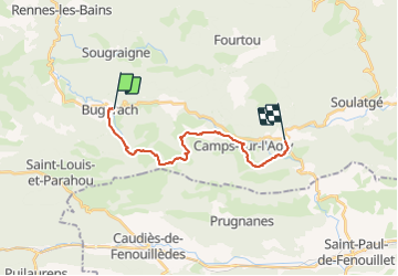

Length
17.8 km

Max alt
912 m

Uphill gradient
754 m
Km-Effort
28 km

Min alt
430 m

Downhill gradient
783 m
Boucle
No
Creation date :
2021-11-01 18:20:09.731
Updated on :
2021-11-01 18:21:16.5
6h20
Difficulty : Medium

FREE GPS app for hiking
 SityTrail
IGN / Geographical institutes
SityTrail Plus
The world is yours!
About
Trail On foot of 17.8 km to be discovered at Occitania, Aude, Bugarach. This trail is proposed by RoMo.
Positioning
Country:
France
Region :
Occitania
Department/Province :
Aude
Municipality :
Bugarach
Location:
Unknown
Start:(Dec)
Start:(UTM)
447211 ; 4747202 (31T) N.
Comments