


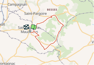
Herault - St-Pons-de-Mauchiens 13km 190m

RandoVal
User

Length
12.9 km

Max alt
191 m

Uphill gradient
218 m
Km-Effort
15.8 km

Min alt
71 m

Downhill gradient
218 m
Boucle
Yes
Creation date :
2021-11-02 14:23:02.39
Updated on :
2021-11-02 14:24:41.901
--
Difficulty : Unknown

FREE GPS app for hiking
 SityTrail
IGN / Geographical institutes
SityTrail Plus
The world is yours!
About
Trail Walking of 12.9 km to be discovered at Occitania, Hérault, Saint-Pons-de-Mauchiens. This trail is proposed by RandoVal.
Description
Petite boucle entre vignes et garrigue, stationnement et départ petit parking de l'école. sens anti-horaire, ancien PR en pointillé rouge sur les cartes IGN, mais plus de marquage sur les chemins.
Positioning
Country:
France
Region :
Occitania
Department/Province :
Hérault
Municipality :
Saint-Pons-de-Mauchiens
Location:
Unknown
Start:(Dec)
Start:(UTM)
541652 ; 4817659 (31T) N.
Comments