


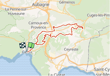
SityTrail - VTT(13)-Rando Cassis 33km

HG74250
User

Length
37 km

Max alt
512 m

Uphill gradient
947 m
Km-Effort
50 km

Min alt
8 m

Downhill gradient
952 m
Boucle
Yes
Creation date :
2021-11-02 17:25:07.306
Updated on :
2021-11-02 18:45:26.288
3h28
Difficulty : Very difficult

FREE GPS app for hiking
 SityTrail
IGN / Geographical institutes
SityTrail Plus
The world is yours!
About
Trail Mountain bike of 37 km to be discovered at Provence-Alpes-Côte d'Azur, Bouches-du-Rhône, Cassis. This trail is proposed by HG74250.
Description
rando au départ de cassis, vigie de la bedoule col de l\'ange, petit rouviere, retour par le départ de l\'offroad PACA.
Positioning
Country:
France
Region :
Provence-Alpes-Côte d'Azur
Department/Province :
Bouches-du-Rhône
Municipality :
Cassis
Location:
Unknown
Start:(Dec)
Start:(UTM)
706285 ; 4787679 (31T) N.
Comments