


Sainte Sigolene Vaubarlay

psesjs
User
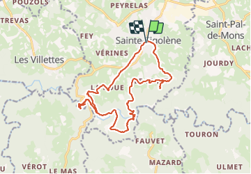

Length
18.9 km

Max alt
818 m

Uphill gradient
558 m
Km-Effort
26 km

Min alt
574 m

Downhill gradient
558 m
Boucle
Yes
Creation date :
2021-10-27 06:54:21.336
Updated on :
2021-11-03 08:11:10.329
5h05
Difficulty : Easy

FREE GPS app for hiking
 SityTrail
IGN / Geographical institutes
SityTrail Plus
The world is yours!
About
Trail Walking of 18.9 km to be discovered at Auvergne-Rhône-Alpes, Haute-Loire, Sainte-Sigolène. This trail is proposed by psesjs.
Positioning
Country:
France
Region :
Auvergne-Rhône-Alpes
Department/Province :
Haute-Loire
Municipality :
Sainte-Sigolène
Location:
Unknown
Start:(Dec)
Start:(UTM)
596952 ; 5010514 (31T) N.
Comments