


la roche percée Merrien

mcterret
User
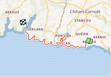

Length
10.7 km

Max alt
24 m

Uphill gradient
125 m
Km-Effort
12.4 km

Min alt
0 m

Downhill gradient
121 m
Boucle
No
Creation date :
2021-11-03 08:00:16.51
Updated on :
2021-11-03 13:59:42.655
3h08
Difficulty : Easy

FREE GPS app for hiking
 SityTrail
IGN / Geographical institutes
SityTrail Plus
The world is yours!
About
Trail Walking of 10.7 km to be discovered at Brittany, Finistère, Clohars-Carnoët. This trail is proposed by mcterret.
Positioning
Country:
France
Region :
Brittany
Department/Province :
Finistère
Municipality :
Clohars-Carnoët
Location:
Unknown
Start:(Dec)
Start:(UTM)
456338 ; 5290707 (30T) N.
Comments