


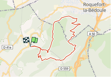
Trail(13)-Cassis - Plan de la Gare Tour du Mont Gibaou

HG74250
User

Length
9.8 km

Max alt
385 m

Uphill gradient
381 m
Km-Effort
14.8 km

Min alt
74 m

Downhill gradient
380 m
Boucle
Yes
Creation date :
2021-11-03 16:40:37.089
Updated on :
2021-11-03 18:51:05.338
--
Difficulty : Medium

FREE GPS app for hiking
 SityTrail
IGN / Geographical institutes
SityTrail Plus
The world is yours!
About
Trail Trail of 9.8 km to be discovered at Provence-Alpes-Côte d'Azur, Bouches-du-Rhône, Cassis. This trail is proposed by HG74250.
Positioning
Country:
France
Region :
Provence-Alpes-Côte d'Azur
Department/Province :
Bouches-du-Rhône
Municipality :
Cassis
Location:
Unknown
Start:(Dec)
Start:(UTM)
707543 ; 4789669 (31T) N.
Comments