


2021-11-04_05h26m03_001 G1 Les 5 Cols de Die

THIOLIER
User
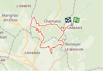

Length
17.8 km

Max alt
777 m

Uphill gradient
737 m
Km-Effort
28 km

Min alt
486 m

Downhill gradient
737 m
Boucle
Yes
Creation date :
2021-11-04 04:26:04.082
Updated on :
2021-11-04 04:26:05.938

FREE GPS app for hiking
 SityTrail
IGN / Geographical institutes
SityTrail Plus
The world is yours!
About
Trail of 17.8 km to be discovered at Auvergne-Rhône-Alpes, Drôme, Romeyer. This trail is proposed by THIOLIER.
Positioning
Country:
France
Region :
Auvergne-Rhône-Alpes
Department/Province :
Drôme
Municipality :
Romeyer
Location:
Unknown
Start:(Dec)
Start:(UTM)
690448 ; 4962908 (31T) N.
Comments