


gaujac oppidum

Dan30
User
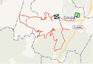

Length
14.3 km

Max alt
265 m

Uphill gradient
317 m
Km-Effort
18.5 km

Min alt
114 m

Downhill gradient
311 m
Boucle
No
Creation date :
2021-11-04 07:33:54.282
Updated on :
2021-11-04 12:42:40.606
4h42
Difficulty : Difficult

FREE GPS app for hiking
 SityTrail
IGN / Geographical institutes
SityTrail Plus
The world is yours!
About
Trail Walking of 14.3 km to be discovered at Occitania, Gard, Gaujac. This trail is proposed by Dan30.
Photos


Positioning
Country:
France
Region :
Occitania
Department/Province :
Gard
Municipality :
Gaujac
Location:
Unknown
Start:(Dec)
Start:(UTM)
626579 ; 4881684 (31T) N.
Comments