


pont saint Maurice roche percée

mcterret
User
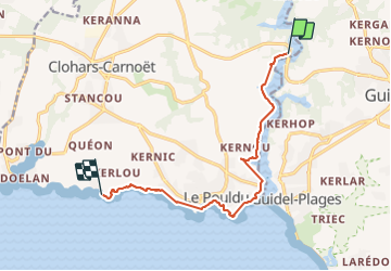

Length
9.8 km

Max alt
30 m

Uphill gradient
127 m
Km-Effort
11.6 km

Min alt
0 m

Downhill gradient
133 m
Boucle
No
Creation date :
2021-11-04 07:43:36.69
Updated on :
2021-11-04 13:24:42.543
2h25
Difficulty : Very easy

FREE GPS app for hiking
 SityTrail
IGN / Geographical institutes
SityTrail Plus
The world is yours!
About
Trail Walking of 9.8 km to be discovered at Brittany, Finistère, Clohars-Carnoët. This trail is proposed by mcterret.
Positioning
Country:
France
Region :
Brittany
Department/Province :
Finistère
Municipality :
Clohars-Carnoët
Location:
Unknown
Start:(Dec)
Start:(UTM)
460784 ; 5293984 (30T) N.
Comments