


gorgesde-l-ardeche

topolino
User
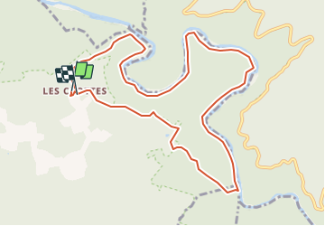

Length
11.6 km

Max alt
272 m

Uphill gradient
613 m
Km-Effort
19.8 km

Min alt
61 m

Downhill gradient
614 m
Boucle
Yes
Creation date :
2021-11-05 08:44:49.158
Updated on :
2021-11-05 08:47:46.4
--
Difficulty : Unknown

FREE GPS app for hiking
 SityTrail
IGN / Geographical institutes
SityTrail Plus
The world is yours!
About
Trail Walking of 11.6 km to be discovered at Auvergne-Rhône-Alpes, Ardèche, Labastide-de-Virac. This trail is proposed by topolino.
Description
Au départ des Crottes, un bel itinéraire sur la rive droite qui longe en partie la rivière. Un passage avec code à signaler mais pas insurmontable...
Positioning
Country:
France
Region :
Auvergne-Rhône-Alpes
Department/Province :
Ardèche
Municipality :
Labastide-de-Virac
Location:
Unknown
Start:(Dec)
Start:(UTM)
614192 ; 4912431 (31T) N.
Comments