


labastide-de-virac-rocher-de-saleyron

topolino
User
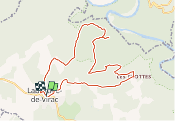

Length
10.8 km

Max alt
400 m

Uphill gradient
274 m
Km-Effort
14.4 km

Min alt
230 m

Downhill gradient
272 m
Boucle
Yes
Creation date :
2021-11-05 08:44:50.943
Updated on :
2021-11-05 08:46:39.365
--
Difficulty : Unknown

FREE GPS app for hiking
 SityTrail
IGN / Geographical institutes
SityTrail Plus
The world is yours!
About
Trail Walking of 10.8 km to be discovered at Auvergne-Rhône-Alpes, Ardèche, Labastide-de-Virac. This trail is proposed by topolino.
Description
Une belle balade sans difficultés à l'ombre des arbres qui va offrir une magnifique vue sur les gorges de l' Ardèche.
Positioning
Country:
France
Region :
Auvergne-Rhône-Alpes
Department/Province :
Ardèche
Municipality :
Labastide-de-Virac
Location:
Unknown
Start:(Dec)
Start:(UTM)
611781 ; 4911806 (31T) N.
Comments