Trail Walking Lagorce - l-arc-perdu-et-notre-dame-d-ajude - Photo

l-arc-perdu-et-notre-dame-d-ajude

 topolino
topolino

User

© OpenStreetMap contributors
Length
Length
9.1 km
Max alt
Max alt
284 m
Uphill gradient
Uphill gradient
245 m
Km-Effort
Km-Effort  
12.4 km
Min alt
Min alt
113 m
Downhill gradient
Downhill gradient
244 m
Boucle
Boucle
Yes
Creation date :
2021-11-05 08:44:51.518
Updated on :
2021-11-05 08:46:22.122

(0 Reviews)

Walking
Walking
--
Difficulty : Unknown

Scan this QR Code to open this trail in the SityTrail application

FREE GPS app for hiking

Logo SityTrail SityTrail

IGN / Geographical institutes

Download SityTrail from the App Store Download SityTrail from Google Play

Logo SityTrail SityTrail Plus

The world is yours!

Download SityTrail from the App Store Download SityTrail from Google Play Download SityTrail on Huawei AppGallery

About

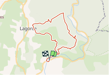
Trail Walking of 9.1 km to be discovered at Auvergne-Rhône-Alpes, Ardèche, Lagorce. This trail is proposed by topolino.

Description

Sortie du 4 juin 2009 effectuée par 15 randonneurs du SCLapalud. Chemin de crête du Ranc de  l'Arc perdu dominant la vallée de l'Ibie: Belle vue. Grosse chaleur. Goûter à l'ombre du majestueux  cèdre de l'Atlas planté devant l'entrée de la Chapelle Notre Dame d'Ajude puis retour par le chemin botanique de Lagorce et le ruisseau de Salustre.  

Elevation profile

Positioning

Country:
France
Region :
Auvergne-Rhône-Alpes
Department/Province :
Ardèche
Municipality :
Lagorce
Location:
Unknown
Start:(Dec)
Start:(UTM)
613775 ; 4921176 (31T) N.


Close
My subscriptions