


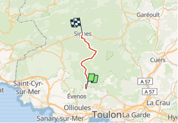
Le broussan- Signes

caroline83150
User

Length
19.6 km

Max alt
781 m

Uphill gradient
569 m
Km-Effort
27 km

Min alt
298 m

Downhill gradient
533 m
Boucle
No
Creation date :
2021-11-05 08:35:15.0
Updated on :
2021-11-05 14:58:24.07
6h22
Difficulty : Very difficult

FREE GPS app for hiking
 SityTrail
IGN / Geographical institutes
SityTrail Plus
The world is yours!
About
Trail Walking of 19.6 km to be discovered at Provence-Alpes-Côte d'Azur, Var, Évenos. This trail is proposed by caroline83150.
Description
Beau parcours , chemin facile avec de sympathiques sous bois . Champignons
Positioning
Country:
France
Region :
Provence-Alpes-Côte d'Azur
Department/Province :
Var
Municipality :
Évenos
Location:
Unknown
Start:(Dec)
Start:(UTM)
733594 ; 4784501 (31T) N.
Comments